WED 1:44PM - updated snowfall map and forecast video posted.
TUES 10:37PM - 00zGFS tonight looks similar to 12zEC. 00NAM moved closer too. Will update my snowfall prediction map tomorrow morning.
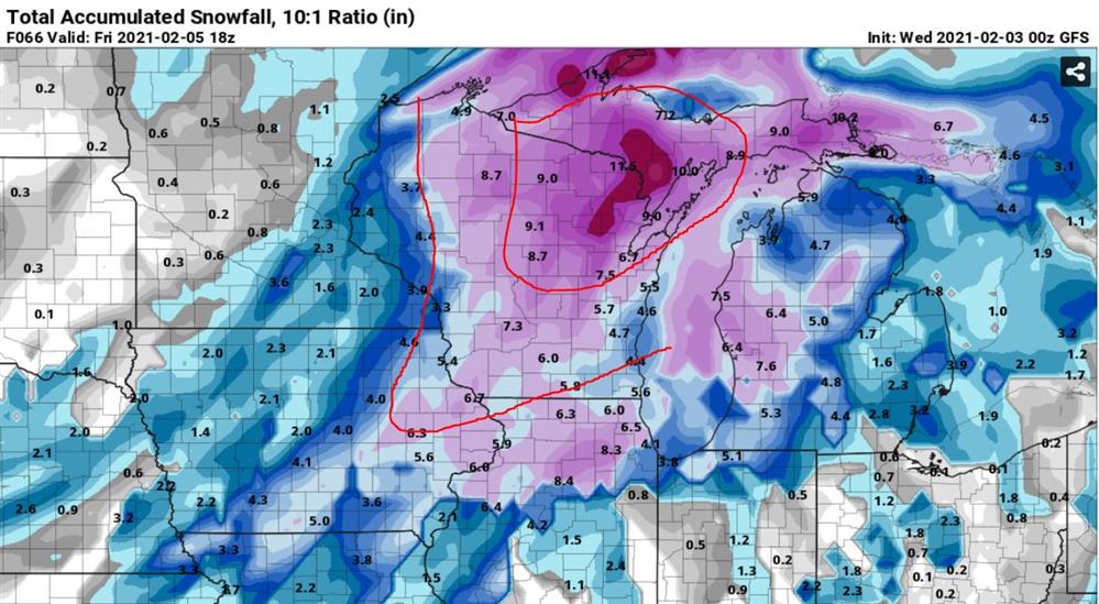
00GFS model simulated snowfall at 10:1. Red lines mark rough 3-6", 6-10" zones.
TUES 2/2/ 2:38PM
Dynamic low pressure system expected to strengthen over the Great Lakes late this week. GFS/EC are most trusted models right now with overall evolution though it is a complex dynamic system likely to be a forecast challenge. Thursday will start with scattered rain/snow mix, transitioning to snow in Wisconsin by THU PM. Friday will turn windy, colder with more snow as the low strengthens over the Lake Michigan region and cold front sweeps through. Several inches of snow accumulation is likely by Friday aft.
GFS is the most aggressive model like usual. I thought EC today was trending that way too but remains more conservative and I'm inclined to lean on that. GFS & EC look similar so that's encouraging. NAM was furthest north and I've kind of ignored it to this stage. Model agreement is poor and overall confidence is low. Seen some progs that bring heavy snow into southern WI but I remain skeptical. I favor northeast Wisconsin for heaviest snows w/ this event.
I believe much could change over the days leading up to the event. Would love to see a GFS reality which would bring snow accumulations in excess of 8" to a large portion of Wisconsin. I took a crack at a snowfall map for Thursday/Friday AM. It's very generalized and likely to change. It reflects the conservative EC 10:1. I will add more detail in the days to come. Watching closely.
Much colder this weekend with strong cold front pushing through following the storm.
I will post a forecast VLOG Wednesday mid-day to discuss this system further in detail.
MON 2/1 3:22PM - A few to several inches of snow is possible with the system for Thursdays into early FRI AM. The EC 10:1 is the more conservative solution, bringing widespread accumulations of a few inches. Other models more aggressive but will not follow that idea just yet. This system has some wrinkles to work out.
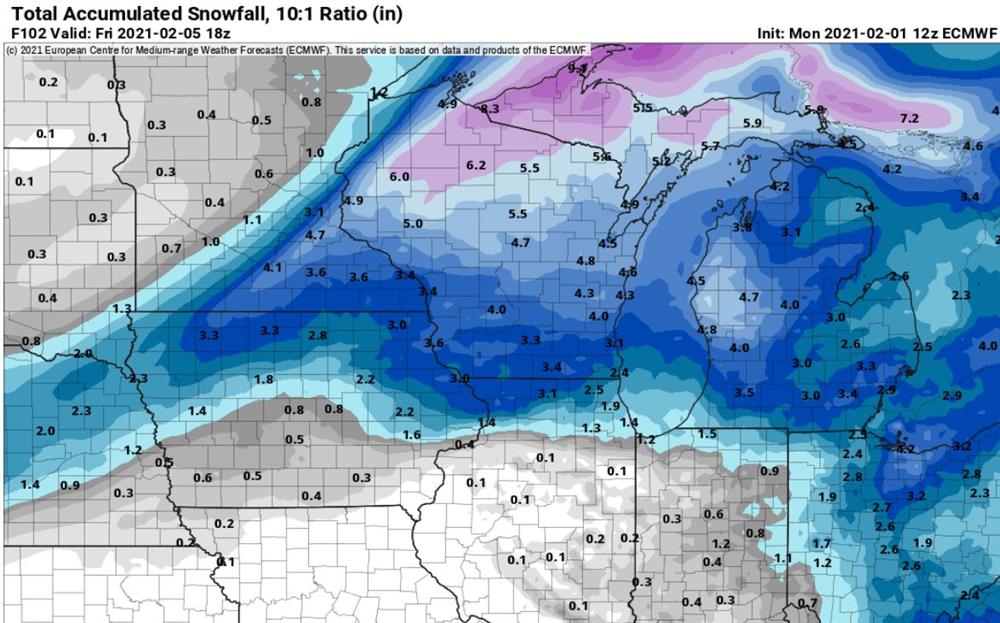
EC 10:1 for late week winter storm.
The cold front to follow will bring in a much colder airmass for the weekend. Strong gusty winds expected on Friday. Keeping an eye on it and will share info when I can.